
Jacksonville, Fl. — THE TROPICS:
***** ALWAYS CHECK & RE-CHECK THE LATEST FORECAST & UPDATES! ****
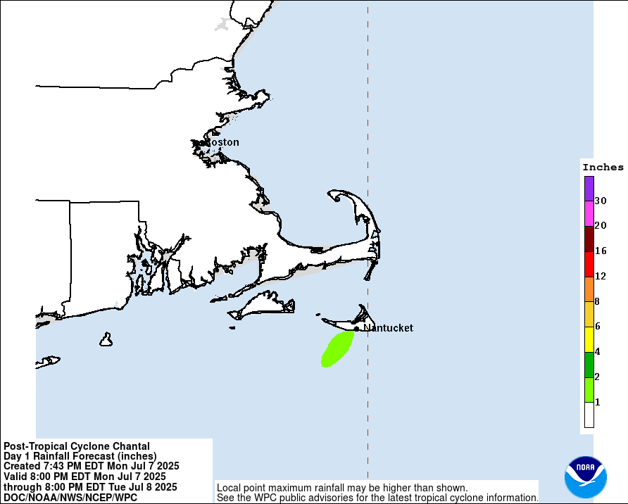
Tropics threats/impacts for Jacksonville/NE Florida/SE Georgia: Tropical storm Chantal is well east/northeast of Jacksonville. Little to no impacts for the local area except for an increased rip current risk at area beaches & slightly stronger breeze into early Sat. evening. Some rain - mostly independent of Chantal - will rotate across the local area on the low’s backside through Saturday but significant impacts are *not* expected. Check back for updated forecasts.
The Atlantic Basin Overview:
The Atlantic hurricane season is June 1st through Nov. 30th.
’92-L’ was upgraded to tropical depression #3 over the Western Atlantic east of the NE FL. & Ga. coasts Fri. afternoon & to tropical storm “Chantal” Sat. morning.
A Tropical Storm WARNING: South Santee River, SC to Cape Fear, NC. Tropical Storm WATCH: Edisto Beach to South Santee River, SC.
The NHC outlined a ‘yellow area’ (low chance for development) in their 8am last Sunday tropical weather outlook that has since been increased to ‘orange’ (medium chance) & went ‘red’ (high chance) early Fri. afternoon before being upgraded to tropical depression #3 late Fri. afternoon & now Chantal. Still no changes in my thinking in what looks to be a weak tropical storm. While the system is over the very warm Gulf Stream, shear is strong - on the order of 20-30+ mph out of the southwest - & should help to limit intensification as well as keep the system tilted more to the east of the center. Forecast models do show lessening shear by Sat. night into Sunday but (1) models are notorious for decreasing strong shear too fast... & (2) Chantal will be making landfall early Sunday morning so has only a short window before running out of warm ocean water.
Recent trends in the models continue to show a bend to the northwest Saturday/Sat. night moving inland over S. Carolina - between Charleston & Myrtle Beach early Sunday. On this track, the Fl. Peninsula remains on the west/weaker side of the low. Somewhat parallel to onshore flow - winds out of the north/northeast - will increase the rip current risk at local beaches - always swim & surf with a buddy & close to a lifeguard as one can. The winds will become offshore cleaning up the surf Sunday. There will be no significant uptick in rainfall *from this system* for Florida (but there will still be the typical summer showers & storms with some coastal showers at night & in the morning due to onshore flow) with a north to south or southwest movement due to the circulation around Chantal.
The Carolina’s will be prone to stronger onshore flow, rough seas & surf, a gusty breeze & some increase in rainfall, especially from middle S. Carolina northward to SE Virginia. But even here - where Chantal will come ashore - impacts generally look to be relatively minor.
Chantal should turn to the northeast after landfall & back over the W. Atlantic early next week though interaction with land does make for some uncertainty on exact track & strength beyond landfall & whether or not there may be some reintensification once back over water. Interaction with an upper level trough may help to strengthen what’s left of Chantal once back over water at which time the system will be moving away from the U.S.


Wilmington N.W.S. radar:

Charleston N.W.S. radar:

Radar imagery courtesy S. Fl. Water Management District:

7-day rainfall forecast:
European & GFS model rainfall forecasts for NE Fl. & SE Ga. through Sunday evening (locally heavier amounts in scattered mostly inland t’storms):


‘Velocity potential anomalies’ below. shows “Rising” air (green lines) equates with an uptick in overall convection. With rising air, conditions are generally more favorable for tropical development. Where there are brown lines, the air is generally sinking & is often less conducive to tropical cyclones (though not impossible to have development).

The “Buresh Bottom Line”: Always be prepared!.....First Alert Hurricane Preparation Guide... City of Jacksonville Preparedness Guide... Georgia Hurricane Guide.
STAY INFORMED: Get the * FREE * First Alert Weather app
FREE NEWS UPDATES, ALERTS: Action News Jax app for Apple | For Android
WATCH “Preparing for the Storm”
WATCH “The Ins & Outs of Hurricane Season”
READ the First Alert Hurricane Center “Preparation Guide”
LISTEN “First Alert Weather: Preparing for the Storm”
Federal Alliance for Safe Homes (FLASH) * here *.
REMEMBER WHEN A TROPICAL STORM OR HURRICANE IS APPROACHING: Taping windows is *not* recommended & will not keep glass from breaking. Instead close curtains & blinds.
Realize the forecast cone (”cone of uncertainty”) is the average forecast error over a given time - out to 5 days - & *does not* indicate the width of the storm &/or where damage might occur.


Water vapor loop (dark blue/yellow is dry mid & upper level air):


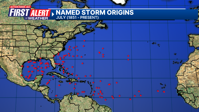
July Atlantic tropical cyclone origins:
Averages below based on climatology for the Atlantic Basin for July:

Wind shear (red - strong shear; green - low shear). Shear is typically strong to start the hurricane season:


Saharan dust spreads west each year from Africa driven by the prevailing winds (from east to west over the Atlantic). Dry air = yellow/orange/red/pink. Widespread dust is indicative of dry air that *can* interfere with the development of tropical cyclones. However, sometimes “wanna’ be” waves will just wait until they get to the other side of - or away from - the dust plume then try to develop if other conditions are favorable (we saw this with Beryl & Debby last year). It’s my personal opinion that there is way too much “hoopla” about the presence of Saharan dust & how it relates to tropical cyclones. In any case, the peak of Saharan dust typically is in June & July, & we are indeed seeing a large “blobs” of Saharan dust over the Central & Eastern Atlantic that’s thinning with westward extent but enough of it to make for hazy skies across the Caribbean & - at times - across parts of Florida.

2025 names..... “Dexter” is the next name on the Atlantic list (names are picked at random by the World Meteorological Organization... repeat every 6 years). Historic storms are retired [Florence & Michael in ’18... Dorian in ’19 (the last time this year’s list was used) ... Laura, Eta & Iota in ‘20 ... Ida in ‘21 ... Fiona & Ian in ‘22... no names were retired in ‘23 for the first time since 2014... & Beryl, Helene & Milton last year in 2024]). The WMO decided - beginning in 2021 - that the Greek alphabet will be no longer used & instead there will be a supplemental list of names if the first list is exhausted (has only happened three times - 2005, 2020 & 2021). The naming of tropical cyclones began on a consistent basis in 1953. More on the history of naming tropical cyclones * here *.

Hurricane season climatology:


East Atlantic:


Mid & upper level wind shear (enemy of tropical cyclones) analysis (CIMMS). The red lines indicate strong shear:

Water vapor imagery (dark blue indicates dry air):

Deep oceanic heat content over the Gulf, Caribbean & tropical Atlantic. The colors will brighten greatly as the water warms to greater depths deeper into the season. It’s worth noting that the deep oceanic heat content right now is not as high as this time last year.

Sea surface temps.:

Sea surface temp. anomalies:

SE U.S. surface map:

Surface analysis centered on the tropical Atlantic:

Surface analysis of the Gulf:

Caribbean:

Atlantic Basin wave period forecast for 24, 48, 72 & 96 hours respectively:


East & Central Pacific:


Central Pacific:

Hawaii satellite imagery:


West Pacific:
Global tropical activity:


“Mun” stays east of Japan:

“Danas” will have impacts on Taiwan the next few days as well as the east coast of China:


Cox Media Group


 Sign Up

